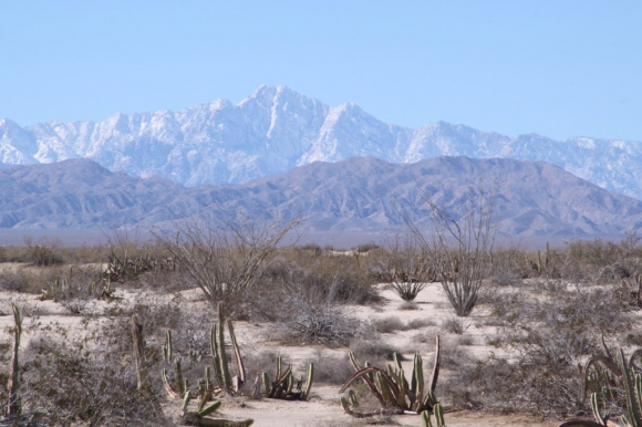
Picacho del Diablo (10,154') in the Sierra San Pedro Martir range to the west of San Felipe.
San Felipe is embraced by the stunning landscapes influenced by the dynamic interactions of tectonic plates.
San Felipe’s dramatic desert landscape, from the rocky coastline of the Sea of Cortez (Gulf of California) to the towering Sierra San Pedro Mártir mountains, tells a story written over millions of years by shifting tectonic plates. The region’s highest peak, Picacho del Diablo (10,154 feet), rises sharply to the west of San Felipe and stands as a monument to the immense geological forces that shaped Baja California. These mountains, canyons, and coastal plains are all part of a living record of the Earth’s restless crust.
Over 30 million years ago, the Pacific Plate and the North American Plate began a slow and powerful separation. This movement created what we now know as the San Andreas Fault System, running northward through California and continuing down into the Gulf of California Rift Zone, right beside San Felipe. That rifting gradually tore the Baja California Peninsula away from mainland Mexico, forming a narrow sea (the Gulf of California) between them. The process continues today: the Baja Peninsula drifts northwestward at roughly 2 inches per year, making the region one of the most geologically active on Earth.
Beneath the surface, ancient volcanic activity sculpted much of the peninsula’s foundation. The Sierra de San Pedro Mártir range, for example, is built from granite and volcanic rock formed deep below ancient volcanoes. To the east, the San Felipe desert basin once lay beneath shallow seas. Fossilized shells and coral fragments still appear in the sands surrounding the town, reminders of when this area was ocean floor. As tectonic uplift and erosion exposed these layers, the land transformed into the arid, sunbaked landscape seen today.
Because Baja California sits directly along the boundary between two major tectonic plates, the area experiences frequent seismic activity. Small tremors are common, and the fault lines that stretch from the Gulf of California through Mexicali and San Felipe are part of the same complex system that extends north into California. These movements are responsible for shaping new coastal features, salt flats, and even minor changes in the shoreline, proof that the region’s geology is still alive and evolving.
San Felipe and the surrounding peninsula are often studied by geologists for their clear evidence of continental rifting, the process that can eventually split continents apart. From rugged mountains to marine terraces, the area is a natural classroom that reveals how Earth recycles and renews itself.
The Gulf of California is one of the youngest seas on Earth — less than 6 million years old. The Baja Peninsula was once part of mainland Mexico before being “carried away” by the Pacific Plate. Some of the volcanic rocks near San Felipe date back over 150 million years. The region’s salt flats and mud volcanoes (found near the Mexicali Valley) are still geothermally active.
Picacho del Diablo (10,154') in the Sierra San Pedro Martir range to the west of San Felipe.
 About
About